- 0 Shopping Cart £ 0.00 -->


Lombok Indonesia Earthquake 2018 Case Study
The causes, effects, and responses to the Lombok earthquake
Lombok is one of the 17508 islands that make up Indonesia. The island is approximately 4,500 sq km (1,700 sq miles) and is located to the east of Bali and west of Sumbawa part of the Lesser Sunda Island chain. It’s known for beaches and surfing spots, particularly at Kuta and Banko Banko (in south Lombok).
In the first in the series, on 29 July, a 6.4 magnitude quake triggered landslides in the mountain region of the island and killed at least 16 people. Following this a shallow, magnitude 6.9 earthquake struck Lombok and Bali on August 5th, 2018, killing over 555 people, injuring 1300 and leaving at least 353000 homeless. The most severe damage was in North Lombok close to the epicentre.
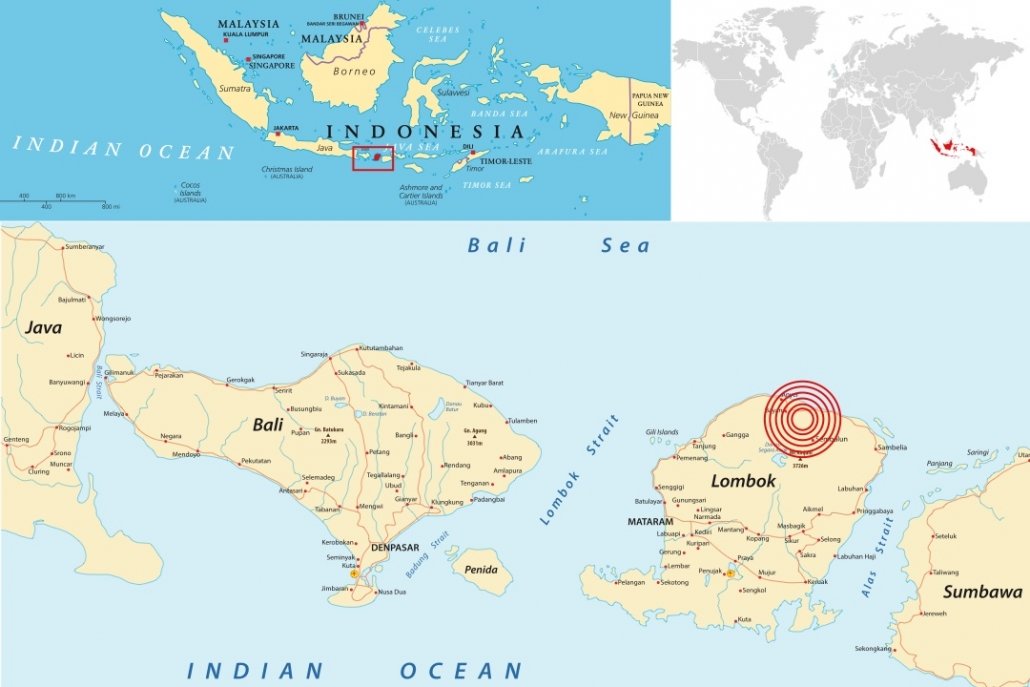
Location of the August 5th 2018 Lombok earthquake
The main quake struck at 19:46 local time (11:46 GMT) on Sunday, August 5th at a fairly shallow depth of 31km (19 miles).
Earthquakes are common in Indonesia because it lies on the Ring of Fire – the line of frequent quakes and volcanic eruptions that circles virtually the entire Pacific Rim.
More than half of the world’s active volcanoes above sea level are part of the ring.
The recent earthquakes have occurred along a specific zone where the Australian tectonic plate meets the Indonesian island plate, Sunda.
Tectonic plates are slabs of the Earth’s crust that move very slowly over our planet’s surface. Indonesia sits along the “Pacific Ring of Fire” where several tectonic plates collide and many volcanic eruptions and earthquakes occur.
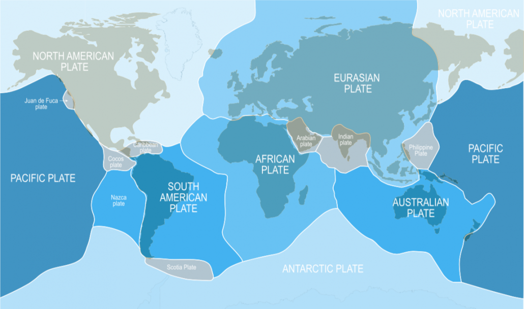
The Earth’s tectonic plates
Some of these earthquakes are very large, such as the magnitude 9.1 earthquake off the west coast of Sumatra that generated the 2004 Indian Ocean tsunami . This earthquake occurred along the Java-Sumatra subduction zone , where the Australian tectonic plate moves underneath Indonesia’s Sunda plate.
Both earthquakes occurred along faults in an area where tectonic plates are colliding, with one diving beneath the other.
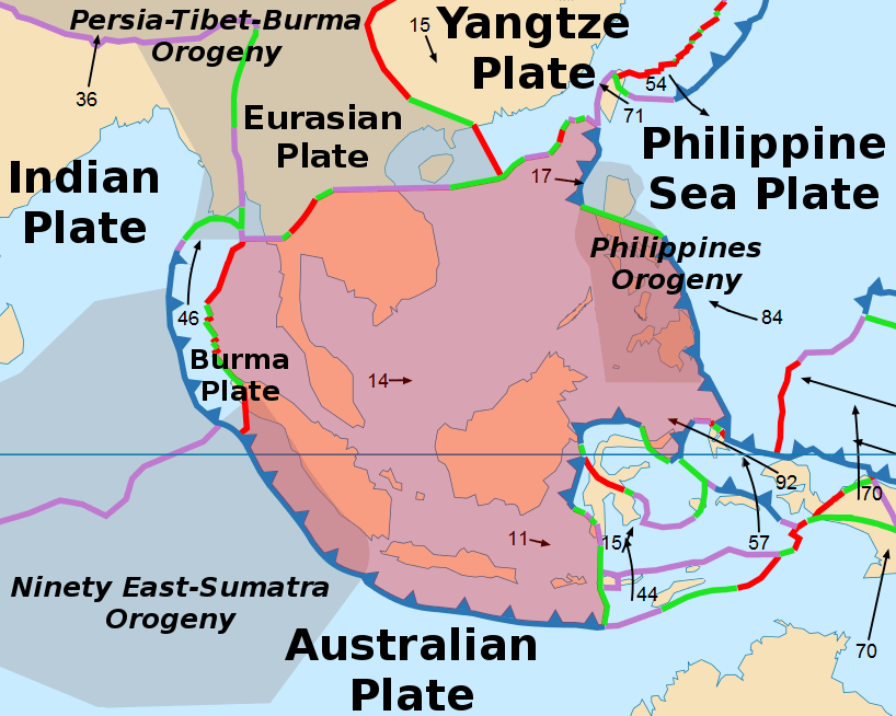
The Sunda Plate
In this area, there’s subduction, so the Australian plate is moving under the Sunda plate, and the Australian plate is moving to the north underneath the Sunda plate.
The earthquake destroyed tens of thousands of homes, mosques and businesses across Lombok on August 5 2018. More than 1,300 people were injured and nearly 353,000 have been internally displaced.
It is estimated that 80% of the region had been damaged by the earthquake. Lombok suffered more than 5 trillion rupiah ($342 million; £268 million) in damage following the 5 August earthquake, authorities said.
Hundreds of tourists were stranded on the island and hotels were filled to capacity. No tourists were reported killed, but the earthquake was felt as far away as the neighbouring island of Bali, where two people died. The quake was followed by more than a dozen aftershocks, with one registering magnitude 5.4 on the Richter Scale.
According to scientists from NASA and the California Institute of Technology’s rapid-imaging project, the earthquake lifted the island as much as 25 centimetres in some areas. In other places, the ground dropped five-15cm.
Emergency teams in East and North Lombok reported that in some villages 75% of homes were damaged.
More than 500 hikers, most of whom were foreigners, were stranded on Indonesia’s Mt Rinjani when a deadly quake triggered landslides. The earthquake triggered landslides around Mount Rinjani, cutting off escape routes. The volcano , which rises 3,726m (12,224ft) above sea level and is the second-highest one in Indonesia, is a favourite among sightseers.
The region was hit by more than 350 aftershocks. Some measured up to 6.2 on the Richter Scale and brought down some buildings.
The area around Mount Rinjani increasingly relies on tourism , the earthquake and aftershocks led to the closure of mountain to hikers leading to many hotel cancellations by international tourists.
Hundreds of British citizens and European citizens were stuck in Lombok airport before flights could resume.
Aftershocks killed at least a further 13 people as the region recovered from the main event.
The Indonesia Government declared a three-week long state of emergency. “The most important thing is the emergency response, after that rehabilitation and reconstruction,” said Indonesia’s second-in-command, Vice President Jusuf Kalla. The government mobilised the National Disaster Mitigation Agency (BNPB) and the national military, directly deploying personnel in response to the earthquake.
Two helicopters were deployed to assist in emergency operations and the military sent troops and medical personnel, as well as medical supplies and communications equipment. Five planes carrying food, medicine, blankets, field tents and water tankers left the capital, Jakarta, for the island early on Wednesday 8th August.
Supplies for those made homeless were distributed with about 30,000 tents and 100 wheelchairs sent to affected areas.
As hospitals and clinics were affected by the earthquake many of the injured were treated in the open air or in makeshift clinics.
Rescue efforts were hampered by power outages, a lack of phone reception in some areas and limited evacuation options. A lack of heavy lifting equipment also affected the relief effort, with some rescuers forced to dig by hand. Other obstacles in the mountainous north and east of Lombok included collapsed bridges and electricity and communication blackouts. Debris blocked damaged roads.
In Sembalun the community pulled together to repair damaged buildings, including the town’s only health clinic. Electricity and clean water had to be being restored to villages in Sambalia that were cut off.
Emergency workers gradually reached more remote areas of Lombok having focussed their initial efforts in urban areas.
More than 500 hikers who were stranded on a mountain on the Indonesian island of Lombok after the earthquake were safely evacuated. Most of the hikers and guides were able to walk down after a safe route was found for them but some were flown out by helicopter.
The UK Foreign Office worked with the Indonesian authorities to provide assistance to British people caught up in the earthquake. Extra flights were added to help people who want to leave Lombok. Airport authorities requested that additional flights be added on Monday 6th August 2018 , to accommodate the influx of tourists trying to leave the island.
Charity, Plan International, provided counselling for children and supported those who were unable to go to school, by distributing emergency school kits and helping teachers continue educating while schools remain closed. The charity also provided humanitarian assistance to 2,500 families in six villages in Lombok. The organisation dispatched 500 emergency shelter kits, containing 1,000 tarpaulins, 1,000 sleeping mats and 2,000 blankets.
The Salvation Army in Indonesia also provided medical and other assistance to people who were affected by the earthquake on Lombok. The team immediately distributed a small supply of rice, noodles, sugar and bottled water to the affected population.
The Indonesian Red Cross (Palang Merah Indonesia) disaster responders provided first aid and assessed immediate needs in remote villages, arranging for bottled water and rice to be delivered by motorbike.
British-based charity Oxfam said it was providing clean drinking water and tarpaulin shelter sheets to 5,000 people and planned to intensify aid delivery.
A French military transport plane delivered 25 tonnes of humanitarian aid to the earthquake-hit island of Lombok on behalf of the Indonesian government.
On the 14th August 2018, The EU announced a further €500 000 to step up its emergency response to meet the most pressing needs of those affected by the devastating earthquakes that struck the Indonesian island of Lombok in late July and early August. The allocation came in addition to the initial €150 000 delivered earlier in August, thus bringing the EU’s contribution to €650 000. The EU humanitarian funding complemented the Indonesian government response and focussed on the most vulnerable groups and communities in the affected area. The EU aid supported the International Federation of Red Cross and Red Crescent Societies (IFRC) in providing relief assistance and protection to the most vulnerable among the affected population. It is estimated that the aid directly benefited 80 000 vulnerable people in some of the worst hit localities in the northeast and west Lombok districts. The aid was also used to assist the IFRC in reuniting families that were separated by the earthquakes. Aid was also offered by other countries including Australia.
Allegedly, authorities on Lombok were demanding money from tourists before they would let them onto rescue boats. However, around 5000 tourists who wanted to be evacuated from three outlying holiday islands had left by boat.

Premium Resources
Please support internet geography.
If you've found the resources on this page useful please consider making a secure donation via PayPal to support the development of the site. The site is self-funded and your support is really appreciated.
Related Topics
Use the images below to explore related GeoTopics.
Amatrice Earthquake Case Study
Topic home, 2018 sulawesi indonesia earthquake and tsunami case study, share this:.
- Click to share on Twitter (Opens in new window)
- Click to share on Facebook (Opens in new window)
- Click to share on Pinterest (Opens in new window)
- Click to email a link to a friend (Opens in new window)
- Click to share on WhatsApp (Opens in new window)
- Click to print (Opens in new window)
If you've found the resources on this site useful please consider making a secure donation via PayPal to support the development of the site. The site is self-funded and your support is really appreciated.
Search Internet Geography
Latest Blog Entries
Pin It on Pinterest
- Click to share
- Print Friendly

Case Study: Predicting the Next Big Earthquake
Recent earthquake activity.
USGS Recent Worldwide Earthquake Activity To explore individual earthquakes in more depth, click on the UTC Date-Time field. Show me how Hide Details for accessing USGS Recent Worldwide Earthquake Activity Scroll the list to look over earthquakes that have occurred in the last seven days. To explore individual earthquakes in more depth, follow the COMMENTS links. Scroll to the bottom of the list to view recent Earthquakes plotted on a world map. What is the magnitude of the most recent recorded earthquake? How many earthquakes were recorded for the last seven days? Of those earthquakes, how many were of a magnitude 7.0 or greater? IRIS Seismic Monitor Click on the map to zoom to specific regions. Click on individual earthquakes to see lists of others nearby. Show me how Hide Details for accessing the IRIS Seismic Monitor Click on the map to zoom to specific regions. Click on individual earthquakes to see lists of others nearby. Where are earthquakes concentrated?
Where does Earth Quake?
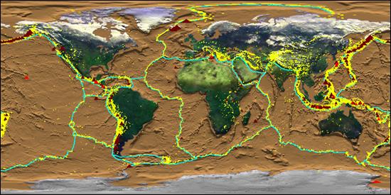
Predicting the Next Big One!
« Previous Page Next Page »
- Investigating Earthquakes with ArcExplorer GIS
- Teaching Notes
- Step-by-Step Instructions
- Tool and Data
- Going Further

- About this Site
- Accessibility
Citing and Terms of Use
Material on this page is offered under a Creative Commons license unless otherwise noted below.
Show terms of use for text on this page »
Show terms of use for media on this page »

- None found in this page
- Initial Publication Date: April 28, 2007
- Short URL: https://serc.carleton.edu/18034 What's This?
Advertisement
Enhancing earthquake disaster risk assessment: insights from pandemic circumstances, case studies, and lessons learned
- Original Paper
- Published: 11 December 2024
Cite this article

- Roberta Apostolska 1 ,
- Vlatko Sheshov 1 ,
- Radmila Salic Makreska ORCID: orcid.org/0000-0003-3571-1139 1 ,
- Marta Stojmanovska 1 ,
- Julijana Bojadjieva 1 ,
- Ana Nanevska 1 ,
- Miodrag Kolic 2 ,
- Darko Mrvaljevic 2 ,
- Kelmend Zajazi 2 ,
- Josip Atalić 3 ,
- Marta Šavor Novak 3 ,
- Miranda Deda 4 ,
- Genci Hoxhaj 4 &
- Adela Krajka 4
83 Accesses
Explore all metrics
The paper presents the outcomes of a unified model, which draws on Khazai et al. (2015), to collect and interpret data related to prevention, preparedness, and response to multi-hazard disasters, with a specific focus on earthquakes and pandemics. The model calculates three urban risk indicators for two case studies: the aftermath of the 2020 earthquake in Zagreb and the 2019 earthquake in Tirana. Its objective is to identify weaknesses in urban resilience and provide guidance for decision-making in disaster risk management. This research is a part of the "Learn to Be Resilient (L2BR)" project, funded by the EU Civil Protection and Humanitarian Aid Operations (101017950 - L2BR - UCPM-2020- KN-AG) with primary aim to strengthen the Union Civil Protection Knowledge Network as a platform for sharing expertise and knowledge in civil protection and disaster risk management. It specifically targeted Southeast Europe, an earthquake-prone region, and prioritized capacity building, intersectoral cooperation, and the enhancement of prevention and preparedness measures. Recent devastating earthquakes worldwide have underscored the importance of effective disaster management, particularly during the COVID-19 pandemic. The case studies on earthquakes in Tirana, Albania, and Zagreb, Croatia, provided valuable data for the research, leading to recommendations for improving operational procedures, particularly in the context of pandemics. The ultimate goal was to elevate disaster and emergency management, saving lives, increasing resilience, and fostering disaster prevention in the region.
This is a preview of subscription content, log in via an institution to check access.
Access this article
Subscribe and save.
- Get 10 units per month
- Download Article/Chapter or eBook
- 1 Unit = 1 Article or 1 Chapter
- Cancel anytime
Price excludes VAT (USA) Tax calculation will be finalised during checkout.
Instant access to the full article PDF.
Rent this article via DeepDyve
Institutional subscriptions

( Source Ministry of Health and Social— https://coronavirus.al/ )

Integrated Disaster Risk Management (IDRM): Elements to Advance Its Study and Assessment

Health Emergency and Disaster Risk Management: Five Years into Implementation of the Sendai Framework
A systematic study of disaster risk in brunei darussalam and options for vulnerability-based disaster risk reduction.
Aliaj Sh. “The November 26, 2019 Mw 6.4 Durres Earthquake and its Relation to Geological Structure of Adria-Albanides Collision Margin”, International symposium on Durrës Earthquake and Eurocodes – ISDEE, Civil Engineering Faculty, Polytechnic University of Tirana, 21–22 September 2020, ISBN 978–9928–4706–0–7
Atalić J, Uros M, Novak Savor M, Demisic M, Nastev M (2021) The Mw5.4 Zagreb (Croatia) earthquake of March 22, 2020, impacts and response. Bull Earthq Eng 19:3461–3489. https://doi.org/10.1007/s10518-021-01117-w
Article Google Scholar
Atalić J., Novak M. Š., Oreb J. and T. Žagar (2022). D.2.2 Case study on City of Zagreb in prevention preparedness, and response to earthquakes, Learn to Be Resilient , 1010017950 – L2BR - UCPM-2020-KN-AG.
Battarra M, Balcik B, Huifu X (2018) Disaster preparedness using risk-assessment methods from earthquake engineering. Eur J Operat Res 269:0377–2217. https://doi.org/10.1016/j.ejor.2018.02.014
CAPRA GIS. Earthquake module, http://www.ecapra.org/software .
Calvi GM, Pinho R (2004) LESSLOSS—a European integrated project on risk mitigation for earthquakes and landslides. IUSS Press, Pavia
Google Scholar
Carreño ML, Cardona OD (2007) Barbat AH (2007b) A disaster risk management performance index. Nat Hazards. 41:1–20
Carreño ML, Cardona OD, Barbat AH (2007a) Urban seismic risk evaluation: a holistic approach. Na Hazards 40(1):137–172
Caunhye M, Nie X, Pokharel S (2012) Optimization models in emergency logistics: a literature review. Soc-Econ Plan Sci Special Issue: Dis Plan Logis: Part 1(46):4–13
Commission E (2016) Action plan on the Sendai framework for disaster risk reduction 2015–2030. Brussels 17(06):2016
Deda M., Hoxhaj, G., and A. Krajka (2022) D.2.3 Case study on City of Tirana in prevention preparedness, and response to earthquakes, Learn to Be Resilient , 1010017950 – L2BR - UCPM-2020-KN-AG.
EEFIT report (2020). THE Mw6.4 Albania earthquake on the 26th of November 2019, Earthquake Engineering Field Investigation Team.
Erdik M (2017) Earthquake risk assessment. Bull Earthq Eng 15(12):5055–5092. https://doi.org/10.1007/S10518-017-0235-2
Freddi F, Novelli V, Gentile R (2021) Observations from the 26th of November 2019 Albania earthquake: the earthquake engineering field investigation team (EEFIT) mission. Bull Earthq Eng 19:2013–2044. https://doi.org/10.1007/s10518-021-01062-8
GIS BUD (2022). GISbased building usability database, Croatian Center for Earthquake Engineering, Faculty of Civil Engineering, University of Zagreb and the Zagreb City (in Croatian).
GRADE Report (2019). M 6.4 Albania Earthquake Global Rapid Post Disaster Damage Estimation (GRADE) report: https://assessments.hpc.tools/assessment/962989f7-01c9-4318-a43c-f36c9fc677a3
HAZUS (1999). HAZUS earthquake loss estimation methodology. Technical Manual . Prepared by the National Institute of Building Sciences for the Federal Emergency Management Agency, Washington DC.
Herak M, Herak D, Orlić N (2022) Properties of the Zagreb 22 March 2020 earthquake sequence: analyses of the full year of aftershock recording. Geofizika 38(2):93–116. https://doi.org/10.15233/gfz.2021.38.6
Herak D, Herak M, Tomljenović B (2009) Seismicity and earthquake focal mechanisms in North-Western Croatia. Tectonophysics 465:212–220. https://doi.org/10.1016/j.tecto.2008.12.005
Herak M, Herak D, Živčić M (2022) Which one of the three latest large earthquakes in Zagreb was the strongest – the 1905, 1906 or the 2020 one? Geofizika 38(2):117–146. https://doi.org/10.15233/gfz.2021.38.5
IGEO. Albanian Seismic Institute - https://geo.edu.al/site/ .
INSTAT (2019), Regional Statistic Yearbook, Albania - http://www.instat.gov.al/al/rreth-nesh/aktivitetet/promovimi-i-aktiviteteve-statistikore/vjetari-statistikor-rajonal-2019-të-dhëna-të-reja-në-nivel-bashkie/ .
ISDR (2006). International strategy for Disaster Reduction - Southeastern Europe Disaster Risk Mitigation and Adaptation Initiative, Risk Assessment for Southeastern Europe , Desk Study Review.
Khazai, B., Bendimerad, F., Cardona, O. D., Carreño, M. L., Barbat, A. H. and C. G. Burton (2015). A Guide to Measuring Urban Risk Resilience: Principles, Tools and Practice of Urban Indicators, Earthquakes and Megacities Initiative , ISBN: 978–621–95288–0–1.
Law (2019) 45/2019 "For Civil Protection"
Leiras A, de Brito Jr I, Queiroz Peres E, Rejane Bertazzo T, Tsugunobu Yoshida Yoshizaki H (2014) Literature review of humanitarian logistics research: trends and challenges. J Human Logis Supply Chain Manag. 4(1):95–130
Markušić S, Stanko D, Korbar T, Belić N, Penava D, Kordić B (2020) The Zagreb (Croatia) M5.5 earthquake on 22 march 2020. Geosciences 10(7):252. https://doi.org/10.3390/geosciences10070252
Ozdamar L, Ertem MA (2015) Models, solutions and enabling technologies in humanitarian logistics. Eur J Oper Res 244:55–65
PDNA report (2020). Albania Post-Disaster Needs Assessment (PDNA), Volume A Report, February 2020, UNDP Albania.
Pitilakis K, Franchin P, Khazai B, H, Wenzel, (2014) SYNER-G: Systemic seismic vulnerability and risk assessment of complex urban, utility, lifeline systems and critical facilities, Methodology and applications, Geotechnical, geological and earthquake engineering. Springer, Heidelberg
RDNA report (2020). Government of Croatia: Croatia Earthquake Rapid Damage and Needs Assessment 2020, Croatia, June 2020.
RISK-UE (2004) The European Risk-UE Project: An advanced approach to earthquake risk scenarios (2001–2004) www.risk-ue.net .
Sheshov V, Apostolska R, Bozinovski Z, Vitanova M, Stojanoski B, Edip K, Bogdanovic A, Salic R, Jekic G, Zafirov T, Zlateski A (2022) Reconnaissance analysis on buildings damaged during Durres earthquake Mw6.4, 26 November 2019, Albania: effects to non-structural elements. Bull Earthq Eng 20:1–23
Sheshov V., Apostolska R., Salic R., Stojmanovska M., Bojadjieva J. and A. Nanevska (2022)a D.2.1 Case Study Methodology, Learn to Be Resilient , 1010017950 – L2BR - UCPM-2020-KN-AG.
Sheshov V., Apostolska R., Salic R., Stojmanovska M., Bojadjieva J. and A. Nanevska (2022)b D.5.5 Planning Draft of Case study on City of TIRANA in prevention preparedness, and response to earthquakes, Learn to Be Resilient , 1010017950 – L2BR - UCPM-2020-KN-AG.
UNDP Ministry of Local Government and Decentralization (2003), Executive Summary “Risk Assessment - Albania” within the “Disaster management and emergency preparedness” Project, 2003.
Vitanova M, Bogdanovic A, Bozinovski Z et al (2022) Seismic performance validation for RC building structures damaged by Durres earthquake, Mw6.4, 26 November 2019 Albania. Bull Earthq Eng 20:6527–6554. https://doi.org/10.1007/s10518-022-01453-5
Yasui A, Numada M, Krishna C (2020) Disaster management process approach: case study by BOSS for disaster response under COVID-19. Nat Hazards. https://doi.org/10.5772/intechopen.94954
Čivljak R, Markotić A, Capak K (2020) Earthquake in the time of COVID-19: The story from Croatia (CroVID-20). J Glob Health. https://doi.org/10.7189/jogh.10.010349
Šavor Novak M, Uroš M, Atalić J, Herak M, Demšić M, Baniček M, Lazarević D, Bijelić N, Crnogorac M (2020) Zagreb earthquake of 22 March 2020 – preliminary report on seismologic aspects and damage to buildings. Građevinar. 72(10):843–867
Download references
Acknowledgements
The L2BR project is funded by the EU's Directorate General for European Civil Protection and Humanitarian Aid Operations (DG-ECHO) through Grant Agreement number 101017950—L2BR—UCPM-2020-KN-AG. The project consortium expresses sincere gratitude for the EU's support, as it has played a crucial role in facilitating the successful implementation and accomplishment of the project's objectives.
Author information
Authors and affiliations.
Institute of Earthquake Engineering and Engineering Seismology, Ss. Cyril and Methodius University in Skopje, Skopje, Republic of North Macedonia
Roberta Apostolska, Vlatko Sheshov, Radmila Salic Makreska, Marta Stojmanovska, Julijana Bojadjieva & Ana Nanevska
Network of Associations of Local Authorities of South-East Europe, NALAS, Skopje, Republic of North Macedonia
Miodrag Kolic, Darko Mrvaljevic & Kelmend Zajazi
Faculty of Civil Engineering, University of Zagreb, Zagreb, Croatia
Josip Atalić & Marta Šavor Novak
Municipality of Tirana, Tirana, Albania
Miranda Deda, Genci Hoxhaj & Adela Krajka
You can also search for this author in PubMed Google Scholar
Corresponding author
Correspondence to Radmila Salic Makreska .
Ethics declarations
Ethical approval.
The Authors affirm ethical responsibility, disclosing conflicts, safeguarding human/animal welfare, and securing informed consent in their research.
Additional information
Publisher's note.
Springer Nature remains neutral with regard to jurisdictional claims in published maps and institutional affiliations.
Rights and permissions
Springer Nature or its licensor (e.g. a society or other partner) holds exclusive rights to this article under a publishing agreement with the author(s) or other rightsholder(s); author self-archiving of the accepted manuscript version of this article is solely governed by the terms of such publishing agreement and applicable law.
Reprints and permissions
About this article
Apostolska, R., Sheshov, V., Salic Makreska, R. et al. Enhancing earthquake disaster risk assessment: insights from pandemic circumstances, case studies, and lessons learned. Nat Hazards (2024). https://doi.org/10.1007/s11069-024-07071-5
Download citation
Received : 16 August 2023
Accepted : 02 December 2024
Published : 11 December 2024
DOI : https://doi.org/10.1007/s11069-024-07071-5
Share this article
Anyone you share the following link with will be able to read this content:
Sorry, a shareable link is not currently available for this article.
Provided by the Springer Nature SharedIt content-sharing initiative
- Urban resilience
- Find a journal
- Publish with us
- Track your research
Earthquake case studies
Earthquake case studies Below are powerpoint presentations discussing the primary and secondary effects and immediate and long-term responses for both the Kobe, Japan and Kashmir, Pakistan earthquakes.
Effects of the Italian earthquake – http://www.bbc.co.uk/learningzone/clips/the-italian-earthquake-the-aftermath/6997.html Responses to Italian earthquake – http://www.bbc.co.uk/learningzone/clips/the-italian-earthquake-the-emergency-response/6998.html The Kobe earthquake – http://www.bbc.co.uk/learningzone/clips/the-kobe-earthquake/3070.html General effects & responses & Kobe (Rich) & Kashmir (Poor)
O Ltb Eartqaukes Cs from donotreply16 Kobe earthquake (Rich country)
Koberevision from cheergalsal Haiti 2010 – Poor country Picture Facts On 12th January, an earthquake measuring 7.0 on the Richter scale struck close to Haiti’s capital Port-au-Prince The earthquake occurred at a destructive plate margin between the Caribbean and North American Plates, along a major fault line. The earthquakes focus was 13km underground, and the epicentre was just 25km from Port-au-Prince Haiti has suffered a large number of serious aftershocks after the main earthquake
Primary effects About 220,000 people were killed and 300,000 injured The main port was badly damaged, along with many roads that were blocked by fallen buildings and smashed vehicles Eight hospitals or health centres in Port-au-Prince collapsed or were badly damaged. Many government buildings were also destroyed About 100,000 houses were destroyed and 200,000 damaged in Port-au-Prince and the surrounding area. Around 1.3 million Haitians were displaced (left homeless)
Secondary effects Over 2 million Habitats were left without food and water. Looting became a serious problem The destruction of many government buildings hindered the government’s efforts to control Haiti, and the police force collapsed The damage to the port and main roads meant that critical aid supplies for immediate help and longer-term reconstruction were prevented from arriving or being distributed effectively Displaced people moved into tents and temporary shelters, and there were concerns about outbreaks of disease. By November 2010, there were outbreaks of Cholera There were frequent power cuts The many dead bodies in the streets, and under the rubble, created a health hazard in the heat. So many had to be buried in mass graves
Short-term responses The main port and roads were badly damaged, crucial aid (such as medical supplies and food) was slow to arrive and be distributed. The airport couldn’t handle the number of planes trying to fly in and unload aid American engineers and diving teams were used to clear the worst debris and get the port working again, so that waiting ships could unload aid The USA sent ships, helicopters, 10,000 troops, search and rescue teams and $100 million in aid The UN sent troops and police and set up a Food Aid Cluster to feed 2 million people Bottled water and water purification tablets were supplied to survivors Field hospitals were set up and helicopters flew wounded people to nearby countries The Haitian government moved 235,000 people from Port-au-Prince to less damaged cities
Long-term responses Haiti is dependent on overseas aid to help it recover New homes would need to be built to a higher standard, costing billions of dollars Large-scale investment would be needed to bring Haiti’s road, electricity, water and telephone systems up to standard, and to rebuild the port Sichuan, China 2008 – Poor country case study Picture On 12th May at 14:28pm, the pressure resulting from the Indian Plate colliding with the Eurasian Plate was released along the Longmenshan fault line that runs beneath. This led to an earthquake measuring 7.9 on the Richter scale with tremors lasting 120 seconds.
Primary effects · 69,000 people were killed · 18,000 missing · 374,000 were injured · between 5 -11 million people were missing · 80% of buildings collapsed in rural areas such as Beichuan county due to poorer building standards · 5 million buildings collapsed
Secondary effects · Communication were brought to a halt – neither land nor mobile phones worked in Wenchuan · Roads were blocked and damaged and some landslides blocked rivers which led to flooding · Fires were caused as gas pipes burst · Freshwater supplies were contaminated by dead bodies
Immediate responses · 20 helicopters were assigned to rescue and relief effects immediately after the disaster · Troops parachuted in or hiked to reach survivors · Rescuing survivors trapped in collapsed buildings was a priority · Survivors needed food, water and tents to shelter people from the spring rains. 3.3 million new tents were ordered.
Long-term responses · Aid donations specifically money – over £100 million were raised by the Red Cross · One million temporary small were built to house the homeless · The Chinese government pledged a $10 million rebuilding funds and banks wrote off debts by survivors who did not have insurance
Earthquakes and tsunamis - Eduqas Case study: Haiti Earthquake, 2021
Earthquakes are caused by the release of built-up pressure at plate boundaries. They can destroy buildings and infrastructure. Tsunamis can also occur, with equally devastating and deadly effects.
Part of Geography Hazardous landscapes
Save to My Bitesize
Case study: Haiti Earthquake, 2021
On 14th August 2021 a magnitude 7.2 earthquake struck Haiti in the Caribbean. The plate boundaries around Haiti are complex. The North American Plate lies to the north and the Caribbean Plate to the south. The earthquake took place at a conservative plate boundary, where the Caribbean plate moved eastwards. The focus was only 10 km deep, and the epicentre was 125 km from the capital Port-au-Prince.
Increased vulnerability – Physical Factors
- Landslides affected the area close to the epicentre, some of which were sizeable. This made it difficult to access some parts of the country.
- A 3 m high tsunami was recorded around the capital, Port-au-Prince.
- Tropical Storm Grace brought heavy rainfall, which hampered relief efforts and caused further problems with mudslides and flooding.
- Liquefaction occurred along many coastal areas and the seaport of Cayes. Liquefaction is when the vibrations from an earthquake cause the ground surface to lose strength and begin to flow like a liquid. More than 50,000 people were affected by liquefaction.
- Social - More than 2,000 died, at least 12,000 were injured and 332 were still missing five days after the earthquake. The delivery of essential aid supplies were hampered by heavy rains from Tropical Storm Grace. Hospitals, schools and homes were destroyed.
- Economic – The estimated cost of damages from the earthquake is around US$1.6 billion. This amounts to 9.6 per cent of Haiti’s GDP.
- Environmental – Hundreds of landslides took place, which destroyed local ecosystems and habitats . Further damage was caused when heavy rainfall from Tropical Storm Grace turned the landslides into mud, leading to widespread flooding.
- 332 people were still missing five days after the earthquake.
- Hundreds of landslides took place, which destroyed local ecosystems and habitats.
- Heavy rainfall from Tropical Storm Grace turned the landslides into mud and led to widespread flooding.
- The United Nations and charities, such as the Red Cross and CAFOD, sent aid. However, the delivery of essential supplies was hampered by heavy rains from Tropical Storm Grace.
- Temporary shelters were provided by the International Organization for Migration. These helped people who had lost their homes.
- The World Food Programme increased their provision of hot meals for school children. This helped to deal with food shortages.
- Temporary hospitals were constructed to help the injured. They also provided routine care, for example, some pregnant women gave birth safely within the temporary facilities.
- The estimated cost of damages from the earthquake is around US$1.6 billion. This amounts to 9.6 per cent of Haiti’s GDP
More guides on this topic
- Plate boundaries - Eduqas
- Volcanoes and volcanic eruptions - Eduqas
Related links
- Geography: Exam practice
- Personalise your Bitesize!
- Jobs that use Geography
- BBC Weather
- Revision Buddies Subscription
- The Royal Geographical Society
- Seneca Learning

IMAGES
COMMENTS
Lombok Indonesia Earthquake 2018 Case Study Overview. Lombok is one of the 17508 islands that make up Indonesia. The island is approximately 4,500 sq km (1,700 sq miles) and is located to the east of Bali and west of Sumbawa part of the Lesser Sunda Island chain.
earthquakes and setting up a crisis coordination help desk to consolidate offers of in-kind support. • Some $11 million in donations, in the form of 243 trucks of food and non-food items,
On average worldwide, about 18 earthquakes per year qualify as big. Seismographs all over the Earth record earthquake activity as it takes place. When predicting where the next big earthquake might occur, seismologists look closely at areas where major earthquakes have occurred in the past, but have not occurred in the last 100 years.
Dec 1, 2021 · Further, the 2017 Ambasa earthquake of magnitude 5.7 caused significant damage to the buildings of Tripura, a northeast state of India. In this context, this paper is an attempt to present a brief overview of these recent earthquakes and the extent of damages suffered by RC, masonry, and mud buildings in the affected areas of Northeast India.
Recent major earthquakes have caused large-scale damage to lives and properties. Insurance will pay for a large part of the damage caused by the recent earthquakes. Insurance consumers and risk managers are eager to understand what actions they can take to better mitigate earthquake risks. Earthquake insurance coverage is still low.
Dec 11, 2024 · The paper presents the outcomes of a unified model, which draws on Khazai et al. (2015), to collect and interpret data related to prevention, preparedness, and response to multi-hazard disasters, with a specific focus on earthquakes and pandemics. The model calculates three urban risk indicators for two case studies: the aftermath of the 2020 earthquake in Zagreb and the 2019 earthquake in ...
Feb 24, 2023 · Here are some case studies that demonstrate the global impact of earthquakes: 1. 2011 Tohoku earthquake and tsunami in Japan: This was a magnitude 9.0 earthquake that struck Japan on March 11 ...
Sichuan, China 2008 – Poor country case study Picture On 12th May at 14:28pm, the pressure resulting from the Indian Plate colliding with the Eurasian Plate was released along the Longmenshan fault line that runs beneath.
Earthquakes and tsunamis - Edexcel Case study - Haiti Earthquake, 2021 Earthquakes are caused by the release of built-up pressure at plate boundaries. They can destroy buildings and infrastructure.
Earthquakes and tsunamis - Eduqas Case study: Haiti Earthquake, 2021 Earthquakes are caused by the release of built-up pressure at plate boundaries. They can destroy buildings and infrastructure.